The UK’s Most Dangerous Road? The Snake Pass
Adverse camber. Undulation. Poor skid resistance. Liable to inclement weather.
These richly allusive, if purely factual phrases, all refer to one stretch of tarmac which traverses the North of England. It is a piece of road which operates as an artery across a green lung of the country, connecting two historically fearsome enemies; the White Rose County of Yorkshire and the Red Rose County of Lancashire. The connecting artery was laid to join the dots over Pennine watershed, across the moorland plateaux where the very highest point manages some 510m above sea level. This is England; the Snake Pass to be precise.
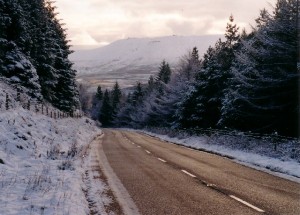
Up there the weather can turn on a sixpence and, when deep in the icy clutches of winter time, travelling across the A57 (as it is more uncommonly known) can be pretty lethal with total whiteouts common and slipping-sliding wheels and snowdrift plunges even more so.
The highest point out on the moors is a far cry from the confines of our cosy little two-up two-down which we have rented for a week while we explore this area of the great English countryside. We’re suddenly very aware that travelling this road is fraught with mishap and almost folkloric tales of motoring woe.
But what a ride.
We take our hire car (no 4x4s left when we arrive unfortunately but I’m happy with my Mini) out from our cottage near the market town of Glossop and head out onto the moorlands with the intention of dodging any more snowfalls and managing to sneak in a picnic somewhere. Failing that, there is always the chance of a bite to eat at the infamous Snake Inn, should we make it that far. Our landlady informs us that the name of the road comes in fact from the pub and not the other way around. The pub, it seems, used to go under the moniker of The Duke of Devonshire (confusing, In know, but this is England remember) and upon the coat of the arms belonging to the Duke of Devonshire a serpent used to dangle. Nowadays, road and pub co-exist in nominal harmony – each reflecting the other.
As we drive up we can see the moorland plateaux of Kinder Scout and Bleaklow nestled in a blemish-less white blanket, the horizon disappearing as the sky merges with the land. The road is clearish until we get a little higher, the camber deceptive and the oncoming traffic a little hairy.
While my partner gazes agape at the flashes of wintry rural beauty around us, I can’t help but notice a little gauze of sweat forming on my palms as I grip the wheel, my forearms tense as rods. I remembered reading that 9/10 of the most dangerous roads were to be found in Northern England. By heck.
As we drive we listen to a song we have downloaded by cult 80s synth-pop band the Human League. The track – ‘The Snake’ – is apparently about this coil of road which remains an important and symbolic highway for dwellers of Sheffield (like The Human League) – The Steel City. The synth arpeggios of the song, the odd tenor of the spoken word vocals offset with the more layered female vocals recreate the twisty-turny rise and fall of the road as we travel. It’s a bizarre experience and for a few careless moments we (OK, I) forget that the tarmac under the rubber of our wheels is glazed with ice.
We spend the afternoon exploring ‘The Sheff’’ which we find to be dripping with cultural activity from street art, to live music leaking out of pubs and a genuine edge we had not seen in any other English city to date. We enjoy ourselves so much that we almost forget to head back over the Snake’s back once again before dark. We just about manage to get back in time before the first flickers of the English winter darkness start to descend.


